
Geomorphotectonic and Seismotectonic Investigation of the Western Segment of the Caspian Fault (Southwestern South Caspian Basin)
Project Leader: Dr. Hamid Nazari
Year: 2012–2017
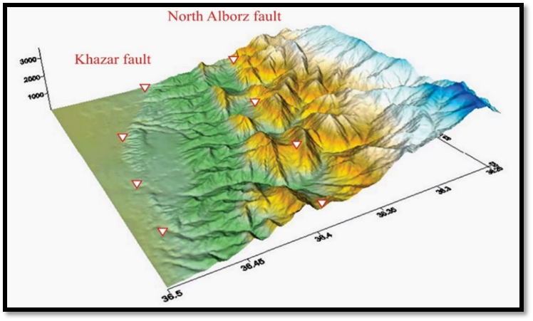
The Caspian Fault, also known as the Khazar Fault, extends for approximately 450 km along the northern margin of the Alborz Mountains and the southern plain of the Caspian Basin (Berberian et al., 1992). Its general trend is approximately east–west; however, due to its southward curvature, its central segment exhibits an arcuate geometry. Although most studies have considered the Alborz Fault to dip southward (Nabavi, 1976; Berberian, 1983), the Tectonic Map of the Middle East (Alavi, 1991) interprets the Caspian Fault as a thrust fault dipping northward. The Caspian Fault separates the Alborz Mountains from the Tertiary basin along the southern margin of the Caspian Sea and may represent the approximate location of the Paleo-Tethys suture (Aghanabati, 2004).
Berberian et al. (1992) attributed the contact between the metamorphic rocks known as the Gorgan Metamorphics and the Quaternary deposits along the southern Caspian coast to the activity of this fault. The Alborz Fault separates the Gorgan–Rasht Zone from the rest of the Alborz. According to Nabavi (1976), activity along this fault dates back to the Silurian and possibly earlier. The Caspian Depression has been subsiding along this fault, and it appears that the depression of the Caspian Sea and the geomorphology of the Gilan and Mazandaran plains may have resulted from movement along the fault, particularly the downward displacement of its northern block.
The Caspian Fault is a fundamental and active fault, and the following historical earthquakes have been attributed to its reactivation (Berberian, 1994):
- 12 November 874 AD, Gorgan earthquake: Ms = 6.0, intensity I₀ = VII+
- 1436 AD, Gorgan earthquake: Ms = 5.3, intensity I₀ = VII
- 1470 AD, Gorgan earthquake: Ms = 5.5
- 1498 AD, Gorgan earthquake: Ms = 6.5, intensity I₀ = VIII
- 3 February 1678 AD, Lahijan earthquake: Ms = 6.5, intensity I₀ = VIII
- 1809 AD, Amol earthquake: Ms = 6.5, intensity I₀ = VIII
Shahpasandzadeh and Zareh (1995) also attributed the destructive 15 August 1485 AD earthquake (25 Mordad 864 SH) in the Daylamestan region of Mazandaran–Gilan to this fault.
Based on seismic data obtained from subsurface geophysical investigations and analysis of seismic data from earthquakes occurring within the Caspian Fault zone, the presence of additional propagating branches of the fault buried beneath the thick sediments of the Caspian seafloor and the Gorgan Plain may be inferred. However, there is currently no evidence demonstrating the Late Quaternary or young activity of all these propagating fault branches (Nazari and Shahidi, 2011).
Tatar et al. (2007) interpreted the Caspian Fault as an independent, single-plane seismogenic fault at depth. In contrast, based on the integration of airborne magnetic and subsurface studies by Brookfield and Hashmat (2001), together with geomorphotectonic studies by Nazari and Ritz (2008) and Nazari (2006), the Caspian Fault has been interpreted as a branch emerging from the North Alborz Fault plane at depth.
Along its length, the Caspian Fault cuts across different topographic levels, producing elevation differences of more than 200 m. These variations in fault-related elevation, measured by Nazari and Ritz (2008), may provide evidence against the interpretation of Guest et al. (2006), who regarded the Caspian Fault scarp as a coastal escarpment rather than a fault scarp.
The Caspian Fault is a thrust fault with a left-lateral strike-slip component. The thrust-slip rate varies from approximately 2 mm/yr in the east to 8 mm/yr in the west, while the left-lateral strike-slip rate ranges from 2 to 5 mm/yr along the fault (Djamour et al., 2010).
Sending comments for this product is not allowed.