
Investigation of the Geomorphotectonic and Seismotectonic Characteristics of the Astara Fault (Western South Caspian)
Project Leader: Dr. Hamid Nazari
Year: 2012–2017
In general, the most prominent topographic feature in the study area associated with the Astara Fault System is the Talesh Mountain Range, which exhibits a significant topographic contrast with the subsiding Caspian Basin as a result of the activity of this fault system. The Talesh Mountains extend in a north–south direction along the western coast of the Caspian Sea in Iran and Azerbaijan, reaching elevations of up to 2,000 m. The eastern flank of the range, owing to its proximity to the Caspian Sea and sufficient moisture, is covered by dense forests. Consequently, erosion in this part is largely confined to riverbeds and drainage channels. This has resulted in a rugged morphology, with very steep mountain slopes and narrow valleys bounded by near-vertical walls.
The western flank of the mountain range, despite its considerable relief, has a gentler morphology than the eastern flank. The mountain slopes are relatively gentle, and the valleys are comparatively broad, all eventually opening onto the Ardabil Plain. The lowest elevation, along the Caspian Sea coast, is approximately 20 m below mean sea level, while the highest point, Hisar-Bolaghi Mountain, reaches an elevation of 3,065 m above sea level.
Based on geomorphotectonic studies, one of the principal causes of the eastward shortening of the Talesh Mountains can be attributed to movement along the Astara Fault Zone. This boundary can also be interpreted as the intersection between the frontal part of the Talesh Mountains and the western part of the South Caspian Basin.
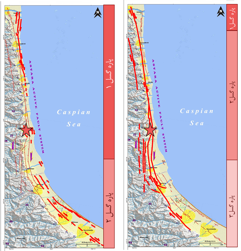
According to the geomorphotectonic and seismotectonic studies of the Astara Fault by Kaveh Firouz et al. (2013), the fault is geometrically characterized as an active fault zone comprising two branches:
- Astara Thrust Fault (ATF): Located along the mountain front and consisting of three fault segments. It has resulted in the overthrusting of Cretaceous and Paleogene units over Quaternary alluvial deposits.
- Astara Strike-Slip Fault (ASF): An active fault comprising two fault segments, located along the western part of the South Caspian coastal plain.
The right-lateral strike-slip mechanism of the Astara Fault, particularly in its northern and central sections where the dominant trend of the fault system is generally north–south, is associated with numerous indications of the formation and development of shutter ridges aligned with the main topographic highs of the Talesh Mountains. These structures occur as progressively developing, narrow, conical folds and ridges enclosed between strike-slip fault segments with differential slip rates and migrating southward.
This continuous displacement over time has resulted in the development of cumulative horizontal displacements ranging from approximately 10 to 1,500 m, particularly along the ATF fault.
Sending comments for this product is not allowed.