
Integration of Environmental Pollution Maps of the Coastal Belt of Gilan Province at a Scale of 1:50,000
Project Director: Dr. Alireza Va'ezi
Year: 2024 (1403)
Client: Geological Survey and Mineral Exploration of Iran (GSI)
Gilan Province is confronted with significant environmental challenges due to its high groundwater table, the discharge of municipal and industrial wastewater, and leachates into rivers and coastal aquatic environments, resulting in widespread contamination of coastal sediments. Within the framework of the Marine Geological Transformation Program of the Geological Survey and Mineral Exploration of Iran, this project was conducted to integrate and complete environmental pollutant maps of the coastal zones of Gilan Province at a 1:50,000 scale. In addition to assessing the geochemical characteristics of coastal sediments, the study investigated the sources of major and trace elements, the degree of contamination, and the ecological risks associated with these elements.
A total of 712 surface sediment samples were collected from eight coastal map sheets, including Astara, Choobar, Talesh, Rezvanshahr, Bandar Anzali, Rasht, Astaneh-ye Ashrafiyeh, and Laskukalayeh. Following field surveys and laboratory analyses, concentrations of major and trace elements were determined using XRD, XRF, ICP-OES/MS, and AFS analytical techniques. The results were subsequently evaluated through statistical analyses, Geographic Information System (GIS) techniques, and environmental assessment indices, including the Enrichment Factor (EF), Modified Degree of Contamination (mCd), and Potential Ecological Risk Index (RI).
The results revealed considerable spatial variability in elemental distributions along the Gilan coastline, with each map sheet exhibiting distinct geochemical characteristics. According to the Enrichment Factor (EF), arsenic (As) was identified as the principal contaminant, showing significant enrichment in the Rezvanshahr, Astara, and Talesh map sheets. Cadmium (Cd) exhibited moderate enrichment in the Laskukalayeh and Rasht areas, while copper (Cu) showed moderate enrichment in Choobar and Astara. In contrast, lead (Pb) displayed little or no significant enrichment across most of the study area.
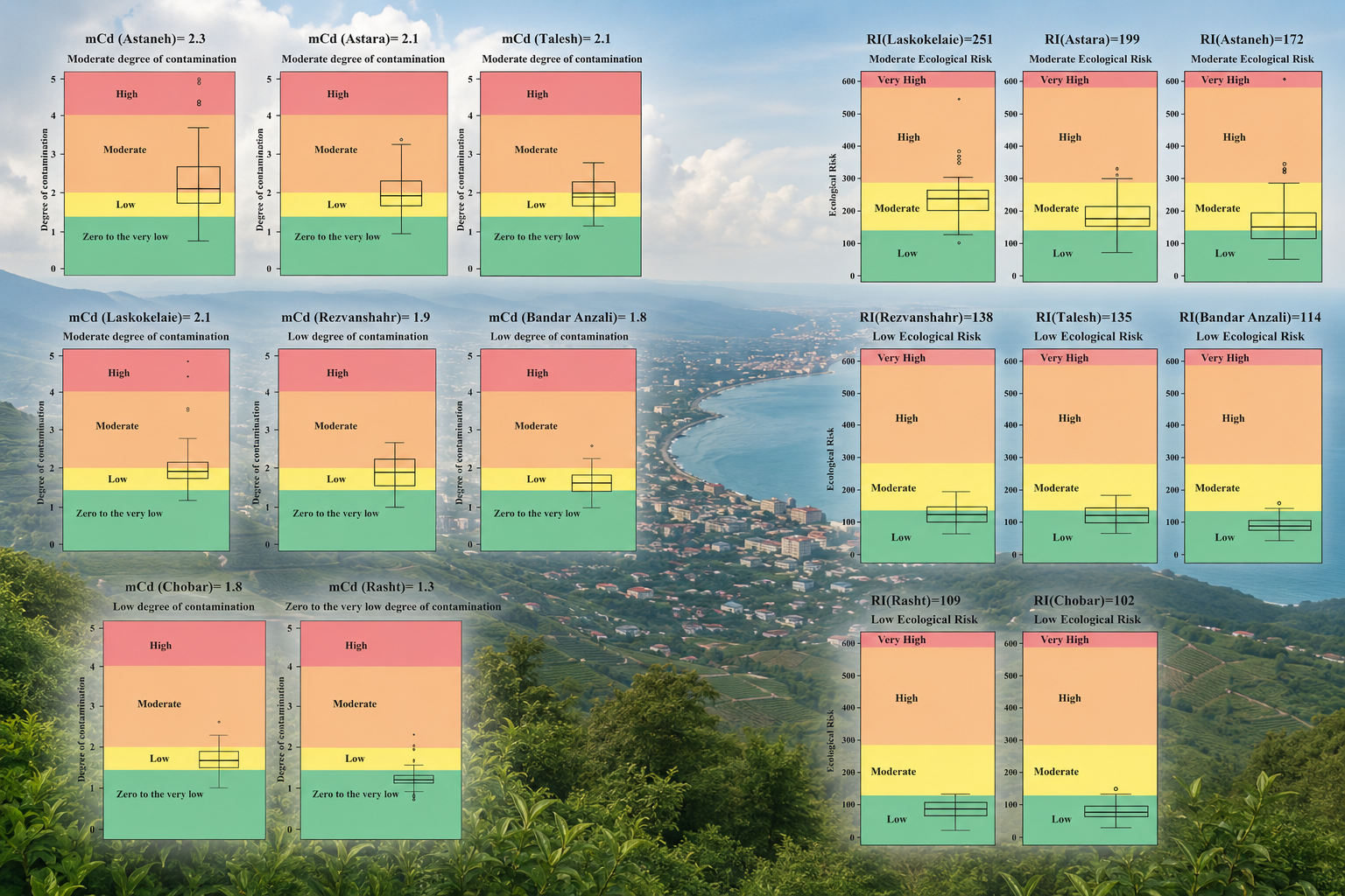
The Modified Degree of Contamination (mCd) indicated moderate contamination levels in the Astara, Talesh, Astaneh-ye Ashrafiyeh, and Laskukalayeh map sheets, whereas the remaining areas were classified as having low to very low contamination. Likewise, the Potential Ecological Risk Index (RI) demonstrated that ecological risk is generally low throughout most coastal areas of Gilan Province but increases to a moderate level in the Astara and Laskukalayeh map sheets. In most locations, arsenic was the dominant contributor to ecological risk, while cadmium represented the primary ecological risk factor in certain areas, particularly Rasht and Laskukalayeh.
Overall, the findings of this study identify the most contaminated coastal zones and the critical pollutant elements, providing valuable information for the completion of marine geological maps, long-term monitoring of coastal pollution, marine environmental management, and the development of sustainable strategies for the conservation and utilization of the coastal resources of Gilan Province.
Sending comments for this product is not allowed.