
Magnetic and Geoelectrical Surveys for Investigation of the North Tabriz Fault and Detection of Its Buried Branches in the Northwestern Part of Tabriz City, Iran
Project Leader: Dr. Mehdi Mohammadi Vizheh
Year: 2024
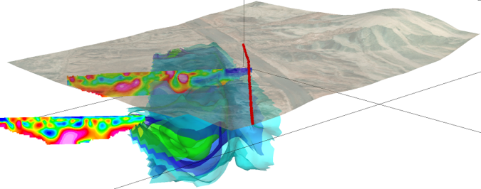
In an area located along the northwestern margin of Tabriz City, the location of the North Tabriz Fault and its concealed branches was identified and refined using magnetic survey data (comprising 401 measurement stations) and two electrical resistivity profiles (including more than 3,000 data points). Considering the magnitude of magnetic variations (314 nT), the presence of igneous units at depth, beneath sedimentary deposits, and/or within conglomeratic units as volcanic clasts is considered plausible.
The results of three-dimensional inversion of the magnetic data indicate the presence of a distinct magnetic susceptibility boundary located approximately 50 m from the North Tabriz Fault. This interpretation is further supported by electrical resistivity results and the distribution of prominent magnetic lineaments. Between the geophysical boundary and the North Tabriz Fault along the mountain front, a low-resistivity zone, interpreted as a fractured zone and/or water-saturated marl units, has been identified. From a tectonic perspective, this entire zone may potentially represent the broader deformation zone associated with the North Tabriz Fault. Considering the sensitivity of this issue and the ongoing development of new structures in the area, further investigations including detailed tectonic studies, trenching, and additional geophysical surveys are recommended. These complementary studies will help answer the key question: “Does the identified geophysical boundary represent the North Tabriz Fault itself, or is it a splay branch derived from a possible basement fault?”
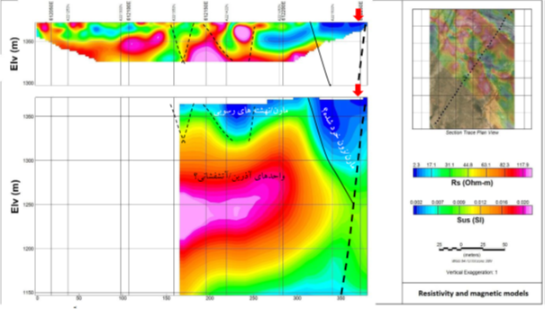
Regardless of the possible presence of strong remanent magnetization, the results suggest that activity along the North Tabriz Fault has likely caused the emplacement of potential volcanic units (with magnetic susceptibility values higher than 0.03 SI) beneath sedimentary deposits and adjacent to marl units. Based on the integrated geophysical evidence, the mapped fault traces can be revised and refined. Furthermore, discontinuities identified in the electrical resistivity models, which are also supported by magnetic lineaments, are recommended for verification during future field investigations and, where necessary, through targeted trenching studies.
Sending comments for this product is not allowed.