
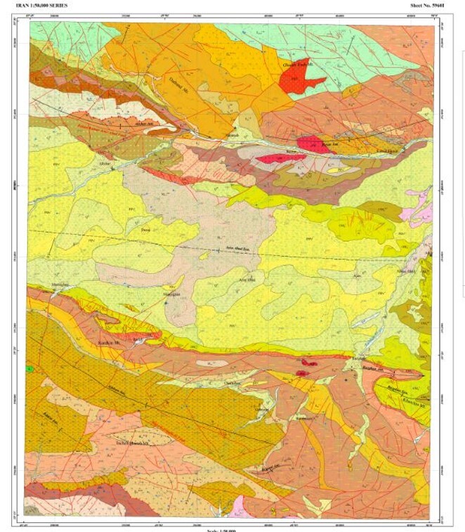
Preparation of the 1:50,000-Scale Geological Map Report of Alishar
Excutor of project: Dr. Mohammad Reza Sheikholeslami
The oldest rock units in the Alishar area are Lower Cretaceous limestones, whereas the youngest deposits consist of recent alluvial sediments. Rock units older than the Cretaceous crop out in the surrounding areas and are unconformably overlain by Eocene volcanic rocks. The extensive volcanic activity in the region represents part of the Urumieh–Dokhtar magmatic arc, which developed in response to the subduction of the Neo-Tethyan oceanic lithosphere beneath Central Iran. Magmatic activity began during the Late Paleocene and reached its peak in the Late Eocene.
The lithological succession is dominated by Eocene volcanic and volcaniclastic rocks, including andesite, basalt, basaltic andesite, dacite, tuff, and ignimbrite. The composition and textures of the Lower to Upper Eocene volcanic and pyroclastic rocks indicate a complex magmatic system produced by successive volcanic eruptions. The occurrence of shallow- to intermediate-marine microfossils indicates that the Eocene volcanism took place within a marine basin. The presence of both shallow- and deeper-water facies suggests that basin subsidence occurred simultaneously with igneous activity during the Eocene.
Magmatic activity in the Alishar area continued into the Oligocene, followed by a widespread marine transgression and deposition of the Qom Formation, consisting mainly of limestone and marl, between the Lower and Upper Red continental clastic formations. Periods of relative volcanic quiescence were accompanied by the deposition of calcareous sandstone, sandy limestone, sandstone, shale, and limestone. Based on the identified microfossils, the Eocene rock units within the Alishar map sheet have been subdivided into Lower, Middle, and Upper Eocene successions.
The various rock units of the area were folded and faulted under compressional tectonic regimes associated with the subduction process, resulting in significant modification of their original stratigraphic attitudes. Faults within the Alishar map sheet display two dominant orientations: northwest–southeast and northeast–southwest. These structures mainly affect the Eocene volcanic units and the Qom Formation. Northwest–southeast-trending faults are predominantly dextral strike-slip faults, whereas northeast–southwest-trending faults are mainly sinistral strike-slip faults.
Large-scale folding within the map area is represented by anticlines and synclines developed in the Eocene and Oligo–Miocene rock units as a result of Miocene compressional tectonic events.
Geochemical investigations indicate that the volcanic rocks range in composition from felsic to intermediate, are predominantly metaluminous, and belong to the calc-alkaline to sub-alkaline magma series. These rocks were generated in a continental magmatic arc developed along the active margin of the Central Iran tectonic zone.
From the perspective of mineralization and economic geology, the Alishar area is considered highly prospective. The volcanic rocks have undergone hydrothermal alteration of varying intensities as a result of ascending magmatic fluids. The principal alteration types associated with mineralization include argillic, silicic, iron oxide, and propylitic alteration. These hydrothermal processes have led to the formation of iron, copper, barite, feldspar, and kaolin mineralization within the study area.
Sending comments for this product is not allowed.