
The importance of preparing geological maps
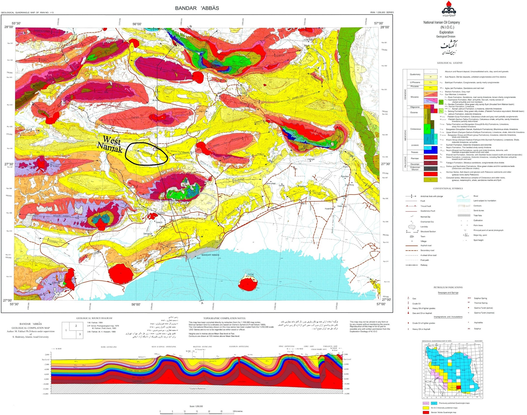
After producing basic geological maps of the country at a scale of 1:250,000 in the early years of the organization's activity and its complete coverage, experts and decision-makers decided to produce more accurate maps in the field of geology and exploration at a scale of 1:100,000 with the aim of producing more appropriate basic information to provide the necessary information to reduce the risk of the private sectors and to promote mining and infrastructure development activities in the country.
Simultaneously with the start of the Fourth, Fifth, and Sixth Development Plans, the preparation of applied geological maps at a scale of 1:25,000 in urban areas and exploration priorities was implemented. Due to the direct need for the implementation of this program for extensive financial resources and appropriate support and due to the lack of allocation in accordance with the plans and capabilities of the organization, the move towards changing the scale of applied maps to a scale of 1:50,000 was reviewed in the final year of the aforementioned plan. On the other hand, the lack of the necessary proportion between the identified needs and the available resources has caused the focus to shift towards creating a suitable platform with global standards and procedures, obtaining maps and publishing them in a shorter period of time, and spending less financial resources. However, the realization of this requires an appropriate structure of financial resources, whether public budget or participation of the private sector and investors in the field of basic information production, which will require a fundamental reform of the structure of activities and budget of the Geological and Mineral Exploration Organization.
The Importance of Preparing Geological Maps
Geological maps are one of the most important basic information of the country, which are used in all development, urban, communication infrastructure, industrial, agricultural, energy, and environmental plans. These maps are prepared at various scales according to their needs and applications, which contain the necessary information for mineral exploration, seismic studies, preparation of natural disaster risk zoning maps, environmental studies, urban development planning, watershed management, industrial and urban location plans, and routing plans for roads and power, energy and water transmission lines.
Undoubtedly, the production of basic geological information and mineral exploration in the form of 380 different information layers (with a unique record among information producing organizations in the country) has played and continues to play a significant role in creating momentum and investment in mining, infrastructure and environmental activities.

Your Comment :