


Active faults around Lut block and their potential for generating earthquake
Executor of project: Dr. Morteza Talebia
2016
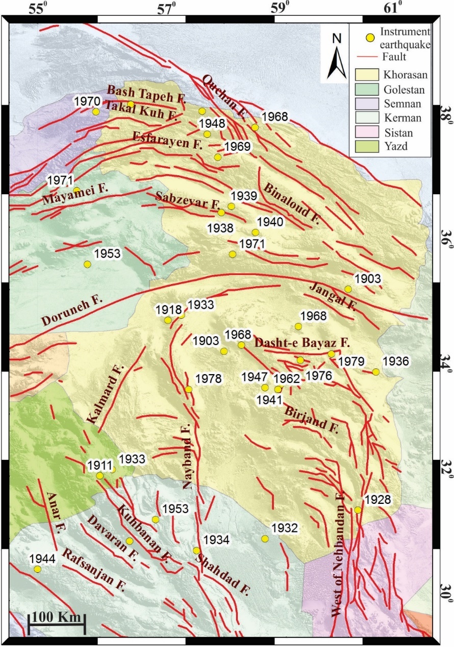
Measurement of the Earth's crustal deformation is carried out by examining the slip rate and active structures in the Quaternary period. The active deformation in Iran is due to the convergence of Arabic and Eurasian plates, with the major deformation and shortage in Zagros, Alborz, Kopeh Dagh and East of Iran. The result of this defromation, in addition to aseismic folding, is a devastating earthquakes. Although destructive earthquakes have occurred due to activity of these active faults, there is often no adequate data of these events. Comprehensive tectonic studies in the area can help identify the sources of these earthquakes. The observation of continental deformation not only provides the opportunity to estimate seismic hazard, but also allows us to find out how the continents respond to tectonic stress, and also provides an insight into the style of brittle deformation in upper crust.
The central Iran block is moving northward at around 13 mm per year relative to Afghan block.. Most of this movement has been distributed on several right faults around the Lut plain, while several active faults are located within this structural zone. From the structural point of view, the center of Iran is one of the areas forming the Iranian plateau. Central Iranian foreskin is surrounded by ophiolitic earthquakes of Sistan, Nain, Baft, Doruneh and ophiolites of Kashmar in Sabzevar. It is surrounded by longitudinal right-longitudinal flaws, which are divided into Lut block, extraterrestrial camel, submerged Tabas, extinct calmard, Alam almond block, Dropdown Bardsir and Bloc of Yazd. Central Iran and the east are composed of several minerals, previously separated by small ocean basins, while the basins started to be closed in Palaeoen. There is evidence that there has been a massive depletion of about 5 million years ago, which can be attributed to the activity of Central-Centralized Fault Strikes. The 13th to 13th millimeter year is a straight cut, centered between Central Asia and Afghanistan, on the northern right-footed faults of the northern southern Nehbandan in the east, Naiband and Gogh in the west of the Lut plain, but above the northern latitudes of 34˚ This straight cut is focused on the faults of the Left and Doreh and Beyday plains. This situation has occurred due to the clockwise rotation in the direction of the shortening of the north of the wisdom of the Central Iranian continent.
In this study, we tried to identify and investigate active faults by using field studies, historical and instrumental earthquake data, and remote sensing and geodetic data. In the following, we interpret the association of these faults in the evolution of this zone An active structure has been addressed. Since earthquakes are phenomena related to the structure and evolution of an area, the study of ancient quakes on the basis of its geology and tectonics, although it is not possible to predict the earthquake, but well-liked areas of future earthquakes show to others.
Sending comments for this product is not allowed.