

Investigation of anion changes, cations, density and elemental dispersion maps in the northern and southern part of Lake Urmia and Analysis of Shahid Kalantari Highway Construction Effect
Executor of project: The Research Institute of Earth Sciences
2019
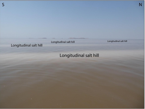
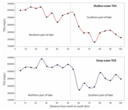
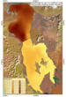
Urmia Lake as the largest hyper-saline lake due to the miss-management of water resources, building up of dam on the rivers and building up the Shahid-Kalantary high way (15 km dike) in the central part of the lake exposed to rapid water level fall and drying down in the last two decade. Building up the Shahid-Kalantary high way in the narrowest (central part) part of the lake, divided the lake into northern and southern parts and caused to the extreme change in the hydrodynamic system, lake current direction and Physico-chemical parameters of lake water. In this study, water depth and lake water Physico-chemical parameters (density, temperature, acidity, electrical conductivity, and total dissolved solids) measurement were done on a systematic sampling network (5 km on 5 km) in the April 20199 Results indicate non-homogenous lake floor topography with three deeper parts in the north, central and southern parts. In general, deep waters show higher density compare to shallow water. In addition, the northern part of the lake contains denser water compere to the southern part of the lake. The temperature of the shallow waters and deep waters are similar. Due to the discharge of 80% of freshwater from the south to the lake, the water of the southern part of the lake is more alkaline compared to the northern part of the lake. Deeper waters of both northern and southern parts of the lake show higher electrical conductivity and total dissolved solids compare to the shallow waters. Also, the lake current was witnessed by the Physicochemical parameters distribution maps, which illustrate the anti-clockwise current direction in the southern part of the lake. Furthermore, the energy of the southern less density water which is passing into the northern denser water from the Shahid-Kalantari Bridge diminishes after a short distance and southern lighter waters mixing with the denser water of the northern part of the lake. Presence of the Shahid-Kalantari dike in the central part of the lake, divided the lake into the northern and southern parts with an independent hydrodynamic system, which is clearly visible on the physicochemical parameters variation profiles with a higher concentration in northern part of the lake, very sharp decreasing in the dike (Shahid Kalantari HighWay place) and lower concentration in the southern part of the lake.
ارسال نظر برای این محصول مجاز نیست.